
Aug 5, 2025
Presidio Parkway: A Century of Transformation
By Rob Thomson, Federal Preservation Officer, Presidio TrustIf there’s one thing you can always count on in the Presidio, it’s change – and the story of the transformation of the Presidio Parkway over the years is a powerful reminder of just how far vision, collaboration, and persistence can take us. July 2025 marks the 10th anniversary of Presidio Parkway, the third anniversary of the opening of Battery Bluff and Presidio Tunnel Tops, and the opening of the new Outpost Meadow picnic area, an extension of all visitors love about Presidio Tunnel Tops and one of the last puzzle-pieces to Presidio Parkway’s transformation.
Points of Interest:
- Community-Driven Process: Planning of the Presidio Parkway involved years of public input, reflecting the priorities of local residents, environmental groups, and civic leaders.
- Tunnels Instead of Towers: The design proposed by the landscape architect and designer Michael Painter featured cut-and-cover tunnels, allowing for open space above so drivers could see the Golden Gate Bridge and bay and the reconnection of the Presidio’s Main Post to the Crissy Field for the first time in decades.
- Efficiency: Construction of Doyle Drive took three years, and during that time the highway was only closed to traffic for 72 hours.
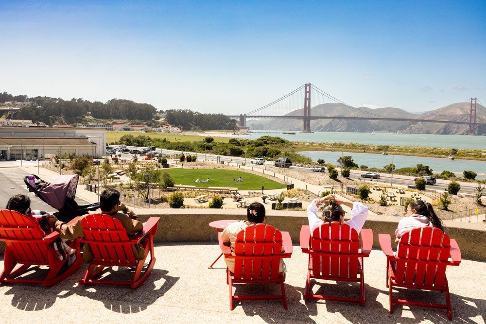
- The Dirt on Presidio Tunnel Tops: 90,000 cubic yards of soil needed to be brought in to build Presidio Tunnel Tops.
- First Greenroads Project: The Presidio Parkway was the first U.S. infrastructure project to receive Greenroads sustainability certification, thanks to its eco-friendly design and materials.
- Innovative Design: Field Operations, also known for the Highline in New York City, designed Tunnel Tops into three landscape zones – a “platform” area with lawns and vistas; a “cliff walk” – a trail with set of overlooks and gathering places that focus visitors on landmarks at vantage points; and the Outpost, an interactive play zone.
- Outpost Meadow, or the 1.5 acres of land that it sits on, is one of the last pieces of Presidio Parkway’s transformation.
A Living Landscape of Change
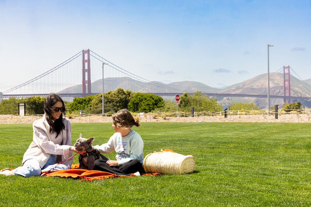
Nestled between Old Mason Street and Presidio Parkway, and near the popular Presidio Sports Basement, is the Outpost Meadow picnic area, a beautiful 1.5-acre open space – and the latest chapter in the Presidio’s evolution.
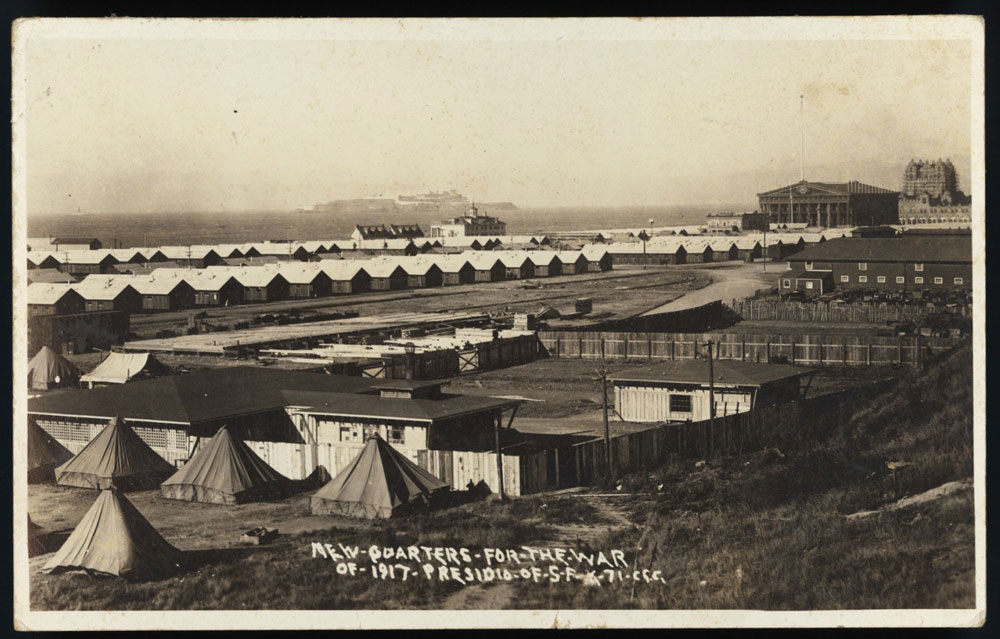
This now vibrant meadow was once marshland in Yelamu, the traditional homeland of the Ramaytush Ohlone. Later, during the early U.S. Army era, the area became a dumping ground for refuse – underutilized land at the edge of a changing Presidio. After the Army filled the marsh in the early 20th century the site housed a horse stable and later a livestock arena for the Pan America Exposition. By World War I, thousands of soldiers lived in a temporary camp here. In World War II, it morphed again – this time into a collection of motor pool buildings for maintaining Jeeps and service trucks. That cycle of reuse and adaptation set the stage for what’s become a crowning achievement of community-led park-making.
VIDEO: Presidio Parkway's Transformation
We recently marked the 10th anniversary of the Presidio Parkway, the scenic highway through the park. While Doyle Drive once separated the Presidio’s Crissy Field from the Main Post, the Parkway integrates seamlessly into the park, winding past wildlife at Quartermaster Reach Marsh and passing through tunnels beneath Battery Bluff and Presidio Tunnel Tops. Watch this brief video to learn more.
Building Bridges
, quality = 95")
, quality = 95")


")
-1000px")
Reimagining the Parkway
The Presidio Parkway, formerly known as Doyle Drive, stretches 1.6 miles and connects San Francisco to the iconic Golden Gate Bridge. Originally built in 1936 as part of the bridge project, it was named after Frank P. Doyle, a key supporter of the bridge’s founding.
Part of the New Deal’s Works Progress Administration (WPA), the project wasn’t just a feat of engineering – it was a testament to a nation building itself out of the Great Depression.
But by the 1970s and ’80s, Doyle Drive was aging and dangerously outdated. The 1989 Loma Prieta earthquake, which closed the Embarcadero Freeway, also shook the very foundation – literally – of Doyle Drive, intensifying calls for change.
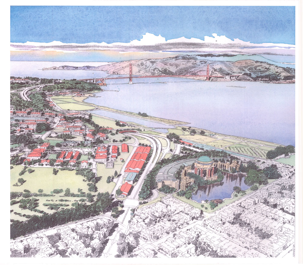
In 1991, the Doyle Drive Task Force was formed to reimagine what this critical connector could be. Led by landscape architect Michael Painter, the vision shifted from a highway slicing through a national park to one that integrated nature, history, and community experience.
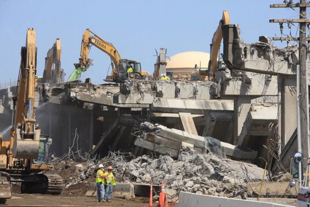
The idea was bold: bury the road in tunnels, reconnect the landscape above, and create world-class public parklands. After the U.S. Army officially transferred the Presidio to the National Park Service in October 1994, President Barack Obama’s post-2008 Great Recession stimulus, and a lengthy community-driven design process, construction finally began in 2009. The old freeway came down in 2012 in a dramatic, crowd-gathering demolition. Utilities were buried, infrastructure was improved, and many historic sites in the Presidio were preserved in the process. By 2015, the new Presidio Parkway opened, with traffic flowing safely beneath what would become Presidio Tunnel Tops.
The new parklands that emerged from this transformation include Quartermaster Reach Marsh, Battery Bluff, and Presidio Tunnel Tops, restoring over 50 acres of natural habitat, trails, gardens, picnic spaces, and panoramic vistas of the Bay and Golden Gate Bridge.
The project was a multi-agency effort, involving the Presidio Trust, Golden Gate National Recreation Area, Golden Gate National Parks Conservancy, Caltrans, San Francisco County Transportation Authority, San Francisco Board of Supervisors, and other agencies. There was also a great deal of philanthropic support from foundations and individuals.
From Freeway to Parklands


Outpost Meadow: The Next Chapter
Outpost Meadow is the newest addition to the Presidio Tunnel Tops experience – an extension of the gathering spaces found at Presidio Tunnel Tops, born directly from visitor feedback and designed by Field Operations. With over 300,000 visitors annually to the Outpost nature play area, families asked for more space to gather, picnic, and relax.
Outpost Meadow picnic area features wheelchair-accessible picnic tables, BBQ grills, stroller and bike parking, drinking fountains, and a wide lawn surrounded by native plant gardens and trees. It’s designed for everyone to enjoy – from kids looking to run free to adults in search of the perfect spot to soak in those unbeatable Golden Gate Bridge views.
And just like the rest of Presidio Tunnel Tops, Outpost Meadow sits on land reclaimed and reimagined – not just from a highway that ran through the Presidio, but from centuries of the Presidio’s layered history. It’s a beautiful example of what’s possible when community, creativity, and care come together.
 Rob Thomson is trained as an archaeologist and historic preservation planner. He has worked for the Presidio Trust since 2006 and currently manages the agency’s historic preservation, archaeology and collections programs as its Federal Preservation Officer. Prior to the Trust, Rob worked for the Getty Conservation Institute, and on archaeological field projects in Virginia, California, and East Africa.
Explore All
YOU'VE VIEWED: 1-0 of 20